and L-Blue Ridge Mountains.
| Introduction |
|---|
Though less glamourous than bald eagles, peregrine falcons, river otters, and other more familiar vertebrates, Tennessee's amphibians have recently acquired an active and dedicated following. In October of 1994 and 1995, the First and Second Annual Tennessee Herpetology conferences were hosted by the Cumberland Mountain Research Center at Lincoln Memorial University. These events, sponsored by the Tennessee Department of Environment and Conservation, Tennessee Wildlife Resources Agency, and Cumberland Mountain Research Center, brought together interested individuals to share information and focus on important conservation issues facing amphibian and reptile populations in Tennessee. Approximately 46 individuals attended the 1994 conference and over 60 attended the 1995 conference. Another important new initiative due to begin in 1996 is the Tennessee Amphibian Monitoring Program (TAMP), sponsored jointly by the Tennessee Department of Environment and Conservation and Tennessee Wildlife Resources Agency.
This atlas should be viewed as a collection of maps intended to provide a sound foundation for the above mentioned efforts and to facilitate future studies into Tennessee's amphibian fauna. In this atlas we provide a brief history of the study of amphibians in the state and distribution maps for 21 species of frogs and 45 species of salamanders. We also provide an overview of questionable and erroneous species reports. The environmental setting of the state is represented by maps showing physiography, climate, drainages, soils, vegetation, and ecoregions. All of these maps were originally developed and presented by Redmond (1985). However, the species' distribution maps have been updated with information collected since 1985.
Considering the pros and cons of delineating species' range boundaries and depicting ranges graphically using stippling or shading, we decided to provide maps showing only dot localities. Those interested in an evaluation and definition of species' ranges in Tennessee should see Redmond (1985) and Conant and Collins (1991).
| Historical Perspective |
|---|
Only two papers concerning Tennessee's amphibian fauna had appeared by 1850. One was Temminck's and Schlegel's (1838) description of Hemidactylium scutatum based on material collected at Nashville. The other, by Troost (1843), was the first list of amphibians for the state.
From 1850 until 1920 Tennessee's amphibian literature expanded slowly, with information accumulating in scattered works ranging in coverage from continental to local. Most notable among the publications of broadest scope were Cope's (1875, 1889) classic papers on North American Batrachia, Packard's (1888) treatise on the cave fauna of North America, Yarrow's (1882) checklist of North American Reptilia and Batrachia, Davis's and Rice's (1883) catalog describing North American Batrachia and Reptilia from east of the Mississippi River, Merrill's (1903) paper on natural history museums (including those at several colleges in Tennessee) of the United States and Canada, Fowler's and Dunn's (1917) account of the salamanders in the collection of The Academy of Natural Sciences of Philadelphia, and Dunn's (1918) review of salamander collections in the Museum of Comparative Zoology at Harvard University. Reports with regional coverage included those by Cope (1870), concerning the fauna of the southern Alleghenies; Mooney (1885-86, 1897-98), on the roles and importance of amphibians and reptiles in Cherokee rituals and myths; Rhoads (1895), concerning amphibian and reptile collections made on a trip across Tennessee; Banta and McAtee (1906), describing the life history of the cave salamander; and Dunn (1917), dealing with salamanders of the genera Desmognathus and Leurognathus. Of more local interest, were Cope's and Packard's (1881) description of the fauna of Nickajack Cave (Marion County), and Blatchley's (1901) paper on a collection of salamanders from southeastern Tennessee, including the descriptions (based on specimens from Sevier County) of taxa now known as Plethodon jordani and Gyrinophilus porphyriticus danielsi.
Information on the amphibians of Tennessee began to mushroom around 1920 and has continued to increase in an ever expanding fashion since. By 1990 there were around 900 titles dealing in one way or another with the subject (Scott, 1991). Several individuals, from amateur naturalists to university professors, have made significant contributions. Frank N. Blanchard and Emmett R. Dunn were dominant among those active during the 1920s. During the 1930s and 1940s six individuals stood out as major contributors. Working in various parts of the state, these were C. L. Baker (Reelfoot Lake), Glen Gentry (statewide), Malcolm V. Parker (western Tennessee), Charles S. Shoup (central and eastern Tennessee), W. H. Weller, and John T. Wood (Great Smoky Mountains National Park and vicinity).
From 1950 through the 1960s Gentry continued to be active and was joined by three others of note: J. R. Endsley (western Tennessee), Robert M. Sinclair (central Tennessee), and Richard M. Johnson (eastern Tennessee). Without reservation, Glen Gentry is considered the father of herpetological studies in Tennessee. Over a span of 31 years he published 13 scientific papers and popular articles. His master's thesis (Gentry, 1937) can be considered the first statewide guide to amphibians. Subsequently he provided two other statewide works (Gentry, 1955-1956; Gentry et al., 1965). Gentry's original field notes cover over 40 years and provide a wealth of information on Tennessee's amphibians. This extensive seven volume set is archived in the Louisiana State University Museum of Zoology.
Since 1970, work has been concentrated in the mountainous regions of eastern Tennessee and areas around state-supported universities with herpetologists on their faculties. Scattered localities harboring state and federally listed species have also received attention. In the eastern mountains, studies have centered on the taxonomy and life history of salamanders. Most prolific among those involved have been Richard Highton, Steven G. Tilley, and David M. Sever. Recent works dealing with amphibians statewide (Redmond et al., 1990; Redmond, 1991) are based mainly on William H. Redmond's doctoral dissertation (1985, The University of Tennessee, Knoxville), which represents the only comprehensive analysis of amphibian biogeography in Tennessee.
Within the university community in Tennessee, a broad array of topics has been investigated. The following professors, with help from many unnamed students (some now professors), have been the stand-outs in this category: Gordon M. Burghardt and Arthur C. Echternacht (University of Tennessee, Knoxville), Jerry W. Nagel (East Tennessee State University), George G. Murphy and Brian T. Miller (Middle Tennessee State University), David H. Snyder and A. Floyd Scott (Austin Peay State University), O. Ray Jordan (Tennessee Technological University), and Joseph S. Jacob and Raymond D. Semlitsch (University of Memphis). Among those monitoring threatened and endangered species in the state the following individuals and government agencies should be mentioned: William H. Redmond, Tennessee Valley Authority; David Withers, Tennessee Department of Environment and Conservation; and R. L. "Pete" Wyatt, Tennessee Wildlife Resources Agency.
| Environmental Setting |
|---|
Environmental factors have played an important role in shaping the distributions of amphibians in Tennessee. To help understand current distributions in relation to the state's environmental setting, the following descriptions and maps of Tennessee's physiography, climate, drainages, soils, vegetation, and ecoregions are provided.
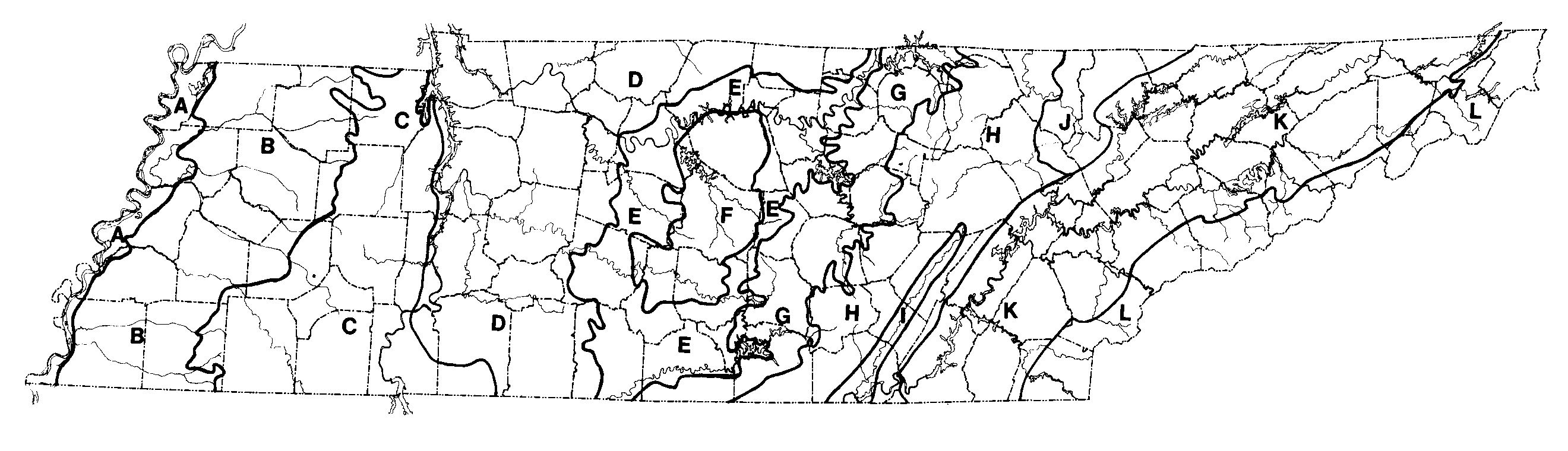
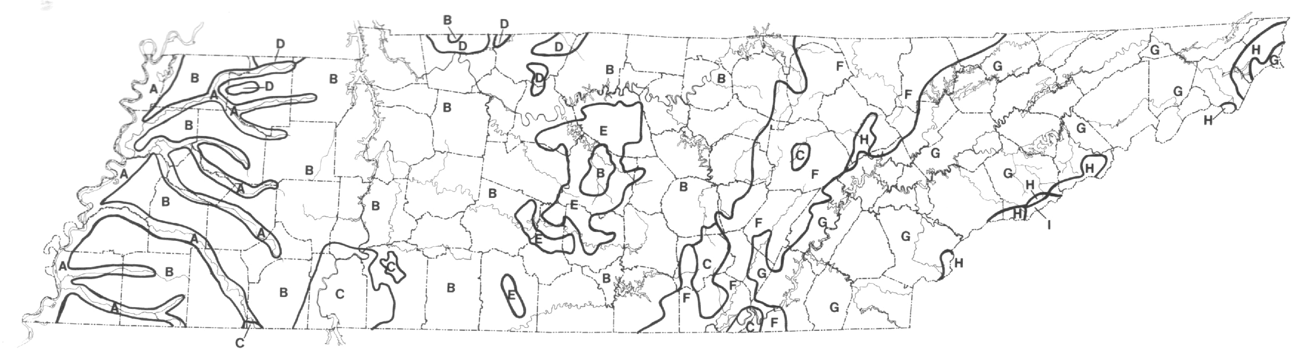
Physiographic features of Tennessee are illustrated in Figure 1. With several modifications, descriptions of these features and their boundaries were taken from Miller (1974). In terms of the physiographic provinces of Fenneman (1938), the features of Tennessee may be categorized as follows. The Mississippi River Valley, Loess Plain, and Coastal Plain Uplands make up the Gulf Coastal Plain Province. The Interior Low Plateaus Province includes the Western and Eastern Highland Rims and the Outer and Inner Central Basins. The Cumberland Plateau, Cumberland Mountains, and Sequatchie Valley make up the Appalachian Plateaus Province. No subdivisions are recognized for the Appalachian Ridge and Valley and the Blue Ridge Mountain provinces.
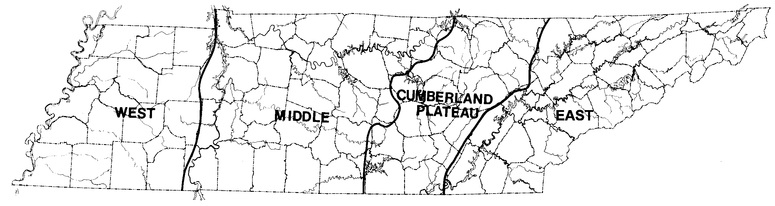
Amphibians are poikilothermic and generally require moist conditions. Temperature and moisture regimes play important roles in the growth and reproduction of amphibians. Detailed climate descriptions are available in Tennessee Department of Finance and Administration (1966) and Dickson (1960). Both of these sources, and the U.S. Department of Commerce (1968), provide maps that show temperature and precipitation trends that are useful for characterizing general climatic variations in Tennessee. Climatic gradients within the state are closely related to topographic characteristics, especially elevation. According to the U.S. Department of Commerce (1968), four climatic divisions, all separated by boundaries running north and south, are recognized in Tennessee. From west to east, these are West, Middle, Cumberland Plateau, and East (Figure 2).
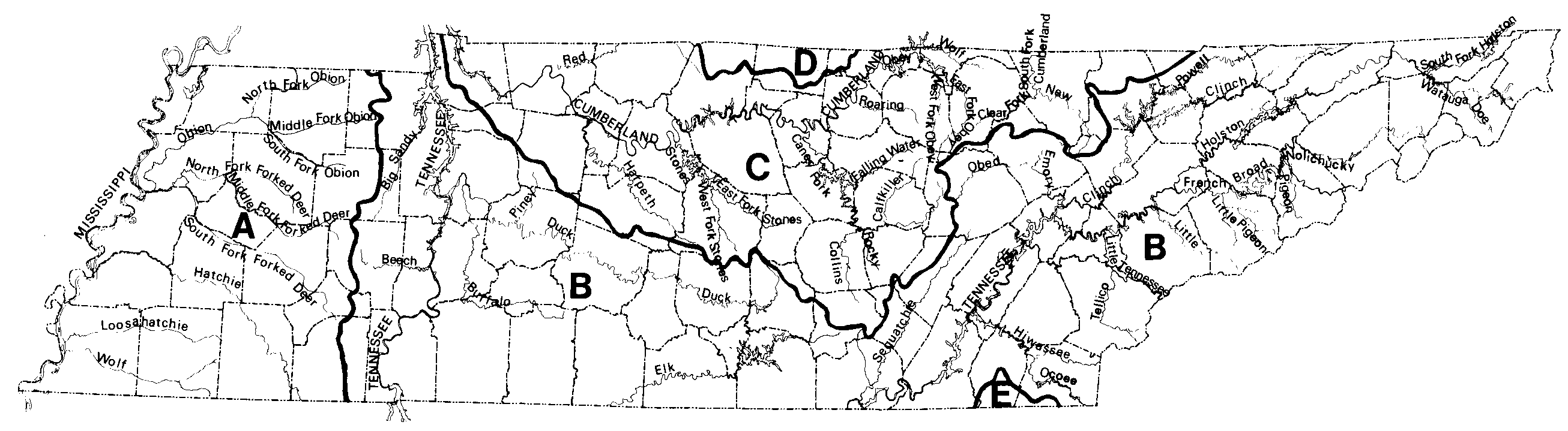
Streams and their associated valley and floodplain habitats can act either as barriers or as corridors for amphibian dispersal. Like other southeastern states, Tennessee has an abundance of surface water. Based on Kernodle (1972), Figure 3 identifies the major streams and their drainage area boundaries. Five major drainage areas occur in Tennessee. These include the Mississippi, Tennessee, Cumberland, Barren, and Conasauga drainages. Most rivers have been modified by channelization in West Tennessee, and by impoundments in Middle and East Tennessee. The largest natural lake is Reelfoot Lake in the northwest corner of the state.
|
|
|
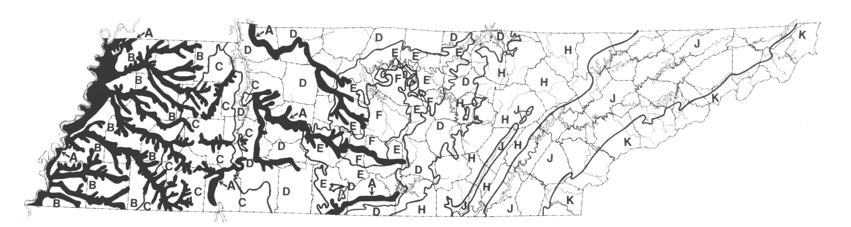
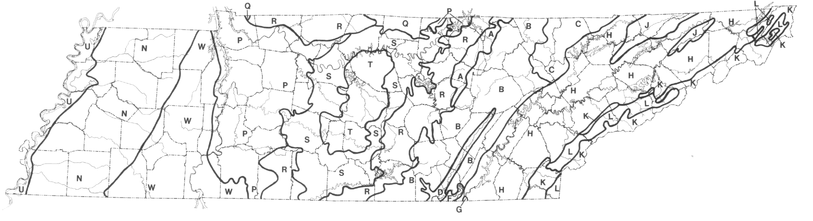
Compared to most terrestrial vertebrates, amphibians have limited dispersal capabilities, and are probably more affected by substrate characteristics. Many forms are predominately fossorial and are directly influenced by soil characteristics. Others are indirectly affected by the soil's influence on vegetation and biotic communities. The soils of Tennessee are diverse, and major soil areas correlate closely with geologic and physiographic regions (Figure 4). General soil areas were taken from Springer and Elder (1980) who recognized nine major soil types.
Vegetative features of Tennessee are discussed both here and under the next section on Ecoregions. We adopted this arrangement after examining and comparing available information on the vegetative regions of the state. Major studies include Braun (1950), Shanks (1958), Kuchler (1964), Bailey (1976), and Fink and Elder (1982). Although these authors used different terminology, they recognized many common boundaries. With the exception of Kuchler (1964), they delineated vegetative boundaries that generally coincide with physiographic boundaries. Because Kuchler's study of potential natural vegetation appears significantly different from the other four studies and relies more on purely vegetative characteristics, its content was used to provide an overview of the vegetative features in Tennessee (Figure 5). Kuchler recognized nine vegetative types in Tennessee. Due to the overall similarity of the other four studies, they are treated together and serve as sources for describing the ecoregions of Tennessee.
Bailey (1976, 1978) developed an ecoregion concept, consisting of a nine-level classification hierarchy, for categorizing and mapping ecosystems in the United States. Bailey and Cushwa (1980) produced a map of ecoregions at the district level for the Appalachian and Tennessee Valley regions. Modifying Bailey's and Cushwa's map, Fink and Elder (1982) utilized a physiographic approach to develop a district level ecoregion map for the Tennessee Valley Region. In Tennessee, they recognized 18 districts (Figure 6). An important feature of ecosystem classifications is the combining of physiographic, geologic, climatic, hydrologic, edaphic, and floristic data in order to delineate ecogeographic units useful in analyzing animal distributions.
Fink and Elder's (1982) ecoregion boundaries correspond closely to the forest and floristic boundaries of Braun (1950) and Shanks (1958). This is evident even though each classification scheme differs in the number of units delineated and the level of detail considered. For example,
|
|
|
|
Fink's and Elder's Blue Ridge High Mountains and Blue Ridge Valleys and Low Mountains districts are essentially identical to Braun's Southern Appalachian Section and Shanks' Unaka Region. Fink's and Elder's classification is the most detailed and recognizes nearly all the areas identified by Braun and Shanks. Thus, any effects of ecoregions on the distribution of amphibians can also be described in terms of the forest and floristic regions of Braun and Shanks.
| Distribution of Species |
|---|
Distribution data were accumulated from three major sources. In order of importance, these were: (1) collections of universities, museums, and other institutions; (2) field surveys; and (3) literature references. Locality data for over 28,000 specimens were obtained from 39 collections (Table 1). Twenty-nine collections were visited, the specimens from Tennessee examined, and the locality data recorded. Information from the remaining 10 collections was acquired by correspondence. Unusual records and/or questionable identifications from the unvisited collections were checked by correspondence with the resident curator or by loan of specimens.
Field surveys by the authors were begun in 1966 and are continuing. Portions of the state receiving the most attention have been those where information on amphibians was most deficient based on existing data from collections and the literature. Priority was also given areas suspected of supporting species whose distributions in Tennessee were considered poorly delineated. All specimens taken by the authors were deposited in the University of Tennessee, Knoxville, Vertebrate Zoology Collection and the Austin Peay State University Museum of Zoology, Clarksville, Tennessee.
The literature search for distribution data involved reviewing approximately 1,100 scientific and popular papers, books, and other articles. Locality data from literature sources were used only when data from museum specimens were unavailable. Files listing all species and locality data used in this study, plus the original distribution maps we constructed from that data, are archived in the Austin Peay State University Museum of Zoology.
| Institution | Abbreviation |
| American Museum of Natural History | AMNH |
| Austin Peay State University | APSU |
| Auburn University Museum | AUM |
| Bays Mountain City Park | BMCP |
| Chicago Academy of Sciences | CAS |
| Carnegie Museum of Natural History | CMNH |
| Chattanooga State Technical Community College | CSTCC |
| East Tennessee State University | ETSU |
| Field Museum of Natural History | FMNH |
| Great Smoky Mountains National Park | GSMNP |
| Illinois State Natural History Survey | INHS |
| Indiana State University | ISU |
| University of Kansas Museum of Natural History | KU |
| Louisiana State University Museum of Zoology | LSUMZ |
| Museum of Comparative Zoology | MCZ |
| Murray State University | MSU |
| Memphis State University Museum of Zoology | MSUMZ |
| Middle Tennessee State University | MTSU |
| North Carolina State Museum | NCSM |
| Northeast Louisiana University Museum of Zoology | NLU |
| Savannah Science Museum | SSM |
| Tennessee Technological University | TTU |
| Tulane University | TU |
| University of Alabama Museum of Natural History | UANH |
| University of Tennessee, Chattanooga | UTC |
| Florida State Museum | UF |
| University of Georgia | UGA |
| University of Illinois Museum of Natural History | UINMH |
| University of Kentucky | UK |
| University of Louisville | UL |
| University of Michigan Museum of Zoology | UMMZ |
| University of North Carolina, Charlotte | UNC |
| University of the South, Sewanee | US |
| United States National Museum | USNM |
| University of Tennessee, Knoxville, Vertebrate Zoology Collection | UTKVZC |
| University of Tennessee, Martin | UTM |
| Virginia Commonwealth University | VCU |
| Virginia Polytechnic Institute and State University | VPI |
| Webb High School Amphibian and Reptile Collection | WSARC |
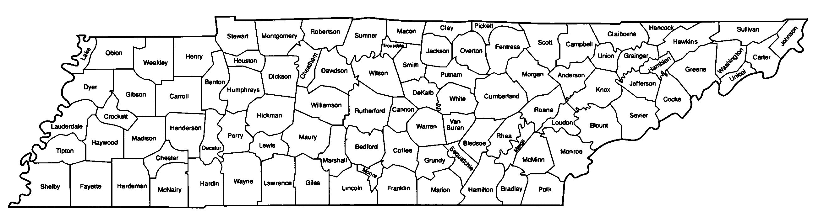
With three exceptions where the known occurrences of more than one species are shown together, each distribution map represents only one species. Maps are arranged alphabetically by order, then by family within each order, by genus within each family, and finally by species epithet within each genus. The small map adjacent to each state map indicates approximate range of the species in the conterminous United States. Scientific and common names used in this atlas follow closely those used by Conant and Collins (1991). Following each species distribution map is information on the species' description, distribution, habitat, and taxonomy. The diagnostic description of each species emphasizes those characteristics found useful in differentiating species, especially closely related ones, found in Tennessee. Unless stated otherwise, length measurements are from Conant and Collins (1991). The taxonomic discussion addresses subspecific variation in Tennessee and, where appropriate, taxonomic and nomenclatural problems and usage adopted. The habitat descriptions are based on (1) data collected during field work, and (2) the literature. A map showing the county names of Tennessee is provided in Figure 7.
|
| Exact locality, based on specimen(s) examined | ||
| Exact locality, based on literature record believed valid | ||
| County record only, based on specimen(s) examined | ||
| County record only, based on literature report believed valid | ||
| Type locality | ||
| ? | Questionable and/or problematic record |
The following comments relate to reports of species that have probably never occurred in Tennessee. Questionable and erroneous records of species presently known from the state, and those considered taxonomically invalid, are discussed in the species accounts accompanying the distribution maps.
Rhoads (1895) noted the southern toad, Bufo lentiginosus, from Davidson and Hamilton counties. He commented on the similarity of specimens from Tennessee and those from the Gulf states. Bufo lentiginosus is a junior synonym of B. terrestris, and in all likelihood Rhoads was referring to what is now known as B. terrestris. Based on his experiences, Gentry (1955-1956) concluded that B. terrestris does not occur in Tennessee, and Blem (1979) illustrated the species as occurring only as far north as northern Mississippi. We have seen no specimens of B. terrestris from Tennessee.
Wright and Wright (1949) provided a distribution map that showed Hyla squirella ranging as far north as the mid-Mississippi and lower Ohio River valleys in West Tennessee, West Kentucky, and southern Illinois. Following Wright and Wright, Gentry (1955-1956) and Gentry et al. (1965) included H. squirella as part of Tennessee's herpetofauna, but noted that they were unaware of valid records for the state. Wright and Wright (1949) probably included West Tennessee in the geographic range of this species based on literature references to museum specimens from southern Illinois and Kentucky. Smith (1961) reviewed these reports and examined the Kentucky specimens. He determined they were actually aberrant Pseudacris triseriata and concluded that H. squirella occurs in neither Illinois nor Kentucky. Conant and Collins (1991) exclude Tennessee from the geographic range of H. squirella.
Bishop's (1943) distribution map for Necturus beyeri included Tennessee River drainages in extreme eastern Tennessee. Gentry (1955-1956), though unable to verify its presence, listed N. beyeri from East Tennessee. Hecht (1958), Gentry et al. (1965), and Conant and Collins (1991) did not consider N. beyeri to occur in Tennessee. During this study, all specimens examined from Tennessee River drainages in East Tennessee were assignable to N. maculosus. Mount (1975) summarized the confusing and often conflicting nature of past taxonomic treatments for the genus. If Mount's taxonomy is accepted, then populations of Necturus in the Conasauga River System (Mobile Drainage) of southeastern Tennessee may prove to be N. beyeri. According to Conant and Collins (1991), Conasauga River populations may be N. alabamensis. No specimens from this area were available during this study.
Several authors have reported Ambystoma jeffersonianum from Tennessee. Rhoads (1895) described 13 individuals collected from Roan Mountain in Carter County. He found numerous specimens under logs at elevations ranging from 1220 to 1585 m. He noted that A. jeffersonianum seemed to replace Plethodon glutinosus at higher elevations. Describing A. jeffersonianum as " bluish black above, dusky below, with a brownish yellow chin and throat," he further stated "there is no spotting, but a close examination shows a light blue pitting along the sides and tail and over the chest and abdomen." Rhoads' specimens are no longer available, but Fowler and Dunn (1917) concluded that they were actually Plethodon metcalfi (now P. jordani). Maldonado-Koerdell and Firschein (1947) reported two specimens (KU Nos. 2642-2643) taken in 1926 from Decatur County. Currently KU No. 2643 is identified as A. texanum and KU No. 2642 has apparently been lost. Three specimens of A. opacum (KU Nos. 2639-2641) were taken from the same locality on the same date. Considering these facts, the report for Decatur County is considered erroneous. Gentry (1955-1956) and Gentry et al. (1965) recorded A. jeffersonianum from Hardeman County, based apparently on one larval specimen (Gentry, 1955-1956) that is now unavailable for verification. Norton and Harvey (1975) acknowledged Gentry's record, but were unable to collect the species in Hardeman County. They somewhat subtly agreed with Bishop (1943) that records south of the general range of the species are possibly A. texanum or some other species. Most recent accounts (Uzzell, 1967; Conant and Collins, 1991) do not consider the species to occur in the state. In view of our failure to verify previous records or to locate specimens from Tennessee, we concur with this conclusion.


APSU Homepage |
APSU Department of Biology |
APSU Center for Field Biology
This document was adapted to the WWW by Rusty Smith and Carol Mayo.