Click on Map for Enlarged View Click for Photo
|
Legend
|
|
| Exact locality, based on specimen(s) or photographs examined | |
| Exact locality, based on literature record believed valid | |
|
|
Approximate locality based on specimen(s) or photographs examined |
|
|
Approximate locality based on literature record believed valid |
|
|
County record only, based on specimens or photographs examined |
|
|
County record only, based on literature report believed valid |
| Type locality | |
| ? | Questionable and/or problematic record |
Taxonomy:
Two subspecies of
Graptemys pseudogeographica are recognized (Iverson et al. 2017).
These include G. p.
pseudogeographica (Northern False Map Turtle) and
G. p. kohnii (Mississippi Map Turtle).
Both coexist in Tennessee, but most populations exhibit a high degree of
intergradation (Vogt 1993, 1995).
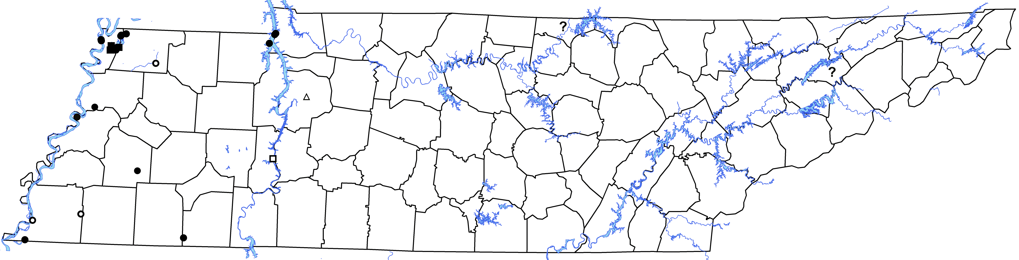
Distribution: False Map Turtles were examined from several
localities in the Mississippi River drainage of western Tennessee and along the
lower Tennessee River in West and Middle Tennessee.
Two isolated literature records, one from the middle Cumberland River
drainage (Clay County) and the other from the upper Tennessee River drainage
(Hamblin County) are not supported by voucher specimens or photographs.
Museum Records by Counties:
Dyer—APSU 19581.
Haywood—APSU
19892. Henry—APSU
853, 854. Lake—AUM 1983, 6285-6287,
20715; CMNH 87582, 87586, 95404-95427, 95432-95437, 95480-95482, 95520, 95522,
95524-95531, 95536, 96065-96078, 96088-96113, 96143-96147, 96160-96180,
101556-101573, 105165-105312, 107613-107623, 107625-107653, 107655-107659,
107669-107707, 107709-107735, 107737-107754, 108717, 108718; FLMNH 74789; KU
204364; TU 16239, 17985, 17986; UIMNH 1271-1275, 1364, 15791; USNM 103471;
UTKVZC 6618, 6619, 6636, 6637; UMMZ 84183. Lauderdale—APSU 19408.
McNairy—APSU
11989.
Obion—APSU
2258; KU 88751, 88758-88763; LSUMZ 34928, 52118, 52119; MoSU R3651, R3652; UMMZ
70727, 74212-74220, 74612-74615, 99607; USNM 102681-102683, 102924-102946;
UTKVZC 3878. Shelby—APSU
12805, 12806; CMNH 76066, 76068. Stewart—APSU 803, 811,
812.
Literature Sources by Counties: Clay—Gentry
(1956).
Decatur—Gentry (1956).
Dyer—Colvin and Dennison (2015b).
Hamblen—Gentry (1956).
Henry—Vogt (1993).
Humphreys—Niemiller
and Reynolds (2013f).
Lake—Parker (1937a, 1948), Moll
(1973), Vogt (1981, 1993), Lamb et al. (1994), Collins et al. (1997), Freedberg
et al. (2005).
Lauderdale—Fulbright et al.
(2013a).
Obion—Parker (1937a,
1948), Bull et al. (1982), Vogt (1993), Collins et al. (1997), Freedberg et al.
(2005).
Shelby—Parker (1948).
Stewart—Vogt
(1993), Lindeman (2003).
Questionable and/or Erroneous Records: Voucher specimens or photographs are needed from the mid-Cumberland and upper Tennessee River drainages to verify Gentry’s (1956) records from Clay and Hamblen counties. Niemiller and Reynolds (2013f) believe records of G. pseudogeographica from middle Cumberland and upper Tennessee River drainages likely represent G. ouachitensis. A record for P. pseudogeographica from Hawkins County (Daniels et al. 2012) was likely based on a misidentified P. ouachitensis (personal communication Peter Lindeman).
Conservation Status: None.
Posted: 7 August 2012
Latest Revision: 18 November 2019
APSU Homepage |
APSU Department of Biology |
APSU Center for Field Biology
This document is being adapted to the WWW by Jean Langley, Floyd Scott, and Rusty Smith.